The Complete Guide to Cenotes: Formation, History & Types
Everything you need to know about what cenotes are, how they were formed, and their significance in Mayan history.
Cenotes are more than just swimming holes; they are geological marvels and sacred cultural sites. In this comprehensive guide, we’ll dive deep into the science and history of these natural wonders.
What are Cenotes?
The Science of Cenotes: A Deep Dive into the Yucatan’s Underworld
Key Points
- Scientific Definition: A cenote is a natural sinkhole resulting from the collapse of limestone bedrock that exposes groundwater underneath. The term is derived from the Yucatec Maya word ts’ono’ot, meaning “water-filled cavity” or “sacred well.”
- Geological Context: They are formed through a process called karstification, where acidic rainwater dissolves porous limestone over millions of years.
- Hydrology: Cenotes are the surface openings of the Great Mayan Aquifer, a vast network of underground rivers. They often feature a halocline, a distinct boundary where fresh water floats on top of denser salt water.
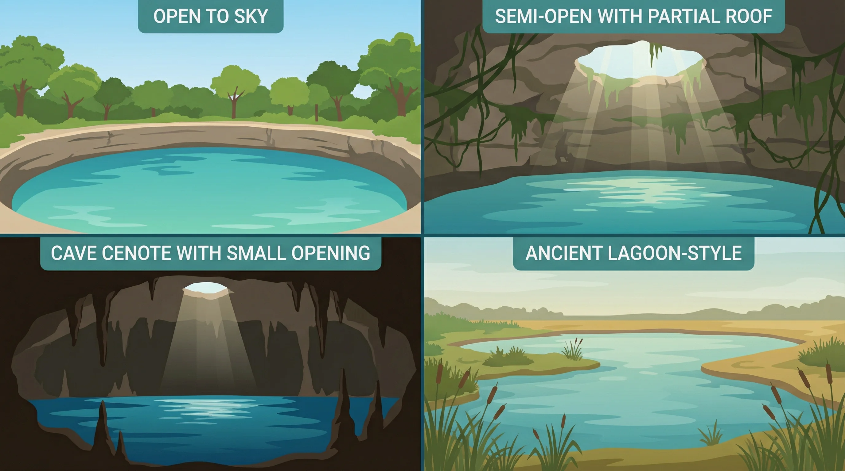
- Evolutionary Stages: Cenotes are categorized by age and the degree of roof collapse: Cave (youngest), Semi-Open (middle-aged), Open (older), and Ancient (oldest/receding).
What is a Cenote? The Scientific Definition
Scientifically, a cenote (pronounced seh-NO-tay) is a dissolution lake or sinkhole formed within karst landscapes. It occurs when the ceiling of an underground cavern collapses, revealing the groundwater table beneath.
Etymology and Cultural Roots
The word is a Spanish transliteration of the Yucatec Maya term ts’ono’ot (or dzonot), which translates to “hole with water,” “abyssal deep,” or “sacred well”. For the ancient Maya, these were not merely water sources in a riverless land; they were spiritual portals to Xibalba, the underworld.
The Formation Process: Karstification
The Yucatan Peninsula is essentially a massive, flat shelf of limestone that was once a coral reef beneath the ocean. The formation of a cenote is a geological process that spans millions of years, driven by karstification:
- Dissolution: Rainwater mixes with carbon dioxide in the atmosphere and soil to form weak carbonic acid.
- Erosion: As this acidic water seeps into the porous limestone bedrock, it slowly dissolves the rock, carving out vast networks of underground tunnels and caves.
- Collapse: Over time””often aided by changing sea levels during Ice Ages that drained the caves and removed the buoyant support of water””the limestone ceilings become too thin to support their own weight. The roof collapses, creating the opening we call a cenote.
The Yucatan Hydrological System
Cenotes are not isolated ponds; they are “windows” into the Great Mayan Aquifer, one of the world’s most complex underground hydrological systems. Because the limestone ground is so porous, the Yucatan Peninsula has no major surface rivers. Instead, water filters down and flows horizontally through subterranean channels.
The “Veins” of the Peninsula
These underground rivers connect thousands of cenotes, moving fresh water from inland areas toward the ocean. The scale is immense; the Sistema Sac Actun (White Cave System) near Tulum is currently recognized as the longest underwater cave system in the world, stretching over 360 kilometers (220+ miles).
The Halocline Phenomenon
A unique characteristic of Yucatan cenotes is the halocline. Because the peninsula is a porous limestone platform surrounded by sea, seawater penetrates inland at depth.
- Stratification: Fresh rainwater, being less dense, floats on top of the denser, saline seawater intrusion.
- Visual Effect: Where these two layers meet (often at depths between 10m to 20m near the coast), they create a distinct visual distortion or “blur” that looks like mixing oil and vinegar. This boundary is the halocline.
The Chicxulub Connection: The Ring of Cenotes
The distribution of cenotes is not entirely random. A high density of sinkholes forms a semicircular arc known as the Ring of Cenotes in northwest Yucatan. This alignment traces the rim of the Chicxulub Crater, the impact site of the asteroid that struck Earth 66 million years ago. The impact fractured the deep limestone, creating a zone of high permeability that directed groundwater flow and accelerated the formation of cenotes along the crater’s edge.
The Four Main Types of Cenotes
Geologists and locals classify cenotes based on their age and the extent of their roof collapse. This classification represents an evolutionary timeline, from the youngest enclosed caves to the oldest open basins.
1. Cave Cenotes (Cenotes Cavernas)
- Evolutionary Stage: Youngest.
- Characteristics: These are almost entirely enclosed underground, accessible only through small openings or tunnels. The ceiling is largely intact.
- Experience: Inside, they often feature spectacular stalactites and stalagmites””formations that could only have grown when the caves were dry during the last Ice Age. They are dark, mysterious, and popular for guided cavern diving.
- Examples: Cenote Choo-Ha, Cenote Mulltum-Ha.
2. Semi-Open Cenotes
- Evolutionary Stage: Middle-aged.
- Characteristics: Part of the limestone roof has collapsed, creating a “skylight” that allows sunbeams to pierce the darkness. They are often shaped like a jug or pitcher (cántaro), with a narrow opening widening into a large water-filled cavern below.
- Experience: These are visually striking due to the contrast between the dark cave and the intense beams of light illuminating the clear water. They offer a blend of open-air swimming and cave exploration.
- Examples: Cenote Ik Kil (often classified here or as open depending on the specific collapse), Cenote Samula.
3. Open Cenotes (Cenotes a Cielo Abierto)
- Evolutionary Stage: Older.
- Characteristics: The roof has completely collapsed, leaving a fully exposed body of water. They resemble natural swimming pools, ponds, or small lakes, often with vertical rock walls (cylindrical cenotes).
- Experience: The water is warmed by the sun, and the edges are often lined with lush jungle vegetation. These are the most accessible for casual swimming and snorkeling.
- Examples: The Sacred Cenote at Chichen Itza, Cenote Azul.
4. Ancient Cenotes (Cenotes Antiguos)
- Evolutionary Stage: Oldest.
- Characteristics: Representing the final stage of the cenote lifecycle, these formations have been exposed to the elements for thousands of years. The walls have eroded to become less steep, and the water may have receded or filled with sediment, creating a lagoon or wetland appearance.
- Experience: They often look more like lagoons (aguadas) with sloping sides and heavy vegetation. In some cases, they may dry up completely during the dry season. They are rich in biodiversity but less commonly used for diving due to sediment and lower visibility.
- Examples: Often found deep in the jungle or appearing as “wetlands” (aguadas) in agricultural areas.